 Camden 1695 map

|

|
|
|
item:- Armitt Library : A6588.2 image:- © see bottom of page |
click to enlarge |
|
|
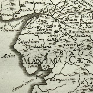
Map, uncoloured engraving, Britannia Romana, Roman
Britain, published by A Swale, The Unicorn, St Paul's
Churchyard, and by A and J Churchil, The Black Swan,
Paternoster Row, London, 1695.
Included in Camden's Britannia, translated and expanded by Edmund Gibson. |
||

|
Camden 1695 map | |
| map feature:- | scroll cartouche & up is N & scale line & lat and long scales (slanted trapezoidal projection; latitude 0 is about 8m W of London, the scale is labelled Degrees from London) & sea plain & coast shaded & rivers & lakes & relief & hillocks & tribal areas & settlements & roman towns | |
| inscription:- |
printed upper left
BRITANNIA / Romana |
|
| inscription:- |
printed with scale line
Milliaria Stadia |
|
| scale line:- | 80 ? = 53.7 mm | |
| scale line:- | 700 ? = 58.1 mm | |
| wxh, page:- | 44x39cm (guess) | |
| wxh, image:- | 357x423mm (guess) | |
| scale:- | ||