 Baines 1829 map

|

|
|
|
item:- Armitt Library : A1107.1 image:- © see bottom of page |
click to enlarge |
|
|
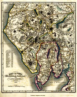
Map, hand coloured engraving, Map of the Lakes of
Westmoreland, Cumberland and Lancashire, scale about 4 miles
to 1 inch, by Charles Fowler, Leeds, engraved by W H Lizars,
Edinburgh, published by W Wales and Co,
Liverpool,Lancashire, 1829.
Tipped in as the frontispiece to a Companion to the Lakes by Sir Edward Baines. |
||

|
Baines 1829 map | |
| map feature:- | up is N & scale line & sea plain & coast shaded & rivers & lakes & relief & hill hachuring & table of heights & woods & forests & parks & county & settlements & roads & sands roads & canals | |
| inscription:- |
printed title
MAP OF THE LAKES / OF / Westmoreland, Cumberland / AND / LANCASHIRE. / Chs. Fowler, Surveyor, Leeds / 1829. |
|
| inscription:- |
printed bottom left, right, centre
Published by W. Wales & Co. Liverpool. / W. H. Lizars Sculpt. Edinr. / For Baines's 'Companion to the Lakes.' |
|
| inscription:- |
printed above the scale line
SCALE. |
|
| scale line:- | 8 miles = 49.1 mm | |
| wxh, sheet:- | 26.5x33cm | |
| wxh, map:- | 243x294mm | |
| scale:- | 1 to 260000 ? (1 to 262215 from the scale line assuming a statute mile) | |