 Hondius 1616

|

|
|
|
item:- JandMN (329) image:- © see bottom of page |
click to enlarge |
|
|
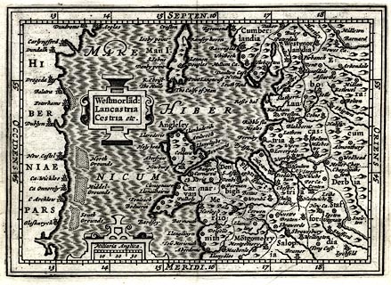
Map, uncoloured engraving, Westmorlandia, Lancastria,
Cestria etc, scale about 45 miles to 1 inch, published by
William Blaeu, Amsterdam. Netherlands, 1639.
The map was included in a version of Britannia by William Camden, abridged by Regner Vitellus. It was originally published by Jodocus Hondius the younger in the 3rd enlarged edn of a miniature world atlas by Petrus Bertius, Petrii Bertii Tabularum Geographicarum Contractarum Libri Septem, 1616. The map was reduced by Jodocus Hondius from his version of the map first drawn by Gerhard Mercator 1595. |
||

|
Hondius 1616 | |
| map feature:- | strapwork cartouche & labelled borders (Latin) & up is N & scale line & lat and long scales & sea moire effect & sandbanks & coast shaded & rivers & relief & hillocks & county & settlements | |
| inscription:- |
printed title cartouche, upper left
Westmorla~d : / Lancastria / Cestria etc. |
|
| inscription:- |
printed with scale line
Miliaria Anglica. |
|
| scale line:- | 30 miles = 16.9 mm | |
| wxh, sheet:- | 14x13cm | |
| wxh, map:- | 134x95mm | |
| scale:- | 1 to 2900000 ? (1 to 2856824 from scale line wrongly assuming a statute mile) | |