 Johnstone 1820

|

|
|
|
item:- private collection (182_1) image:- © see bottom of page |
click to enlarge |
|
|
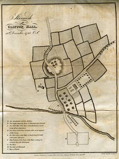
Map, uncoloured engraving, Skirmish at Clifton Hall, 18th
December, 1745, engraved by Sidney Hall, Bury Street,
Bloomsbury, published by Longman, Hurst, Rees, Orme and
Brown, Paternoster Row, London, 1820.
Included in the Memoirs of the Rebellion in 1745 and 1746, by the Chevalier de Johnstone. The map shows troop positions of the rebels and the Duke of Cumberland's forces. Troops are labelled by a letter referring to a table in which phrases 'Our detachment with the Artillery' and 'The 4000 Men of the Duke of Cumberland in march to cut off our detachment' confirm that the map was drawn by a rebel sympathiser. The map has been intrepretted as well as may be by Ian Lewis:- The river probably represents the Eamont, the major river obstacle between Clifton and Penrith. The smaller Lowther which precedes it was probably fordable and thus ignored. ~H~ = Clifton Hall in key, which is absurd. Clifton Hall is at the northern end of the village of Clifton, way south of the river. Indeed if H is the Hall then what is the gentry house on the map? perhaps Lowther Castle? The eminence is probably Brackenber Hill where Butcher Cumberland first appeared at the start of the skirmish. The secondary road running off the old A6 with the advancing Hanoverian troops on it is probably the B5320 from Yanwath. Cumberland sent a flanking force to try the cut off the Highlanders at Eamont Bridge. Apart from that it is difficult to interpret the map. ~The Farm~ is probably an un-named farm where the Chevalier Johnstone found a replacement farm cart when one of the Highlander~s carts fell apart. The map must have been drawn up by memory long after the battle and tries to encompass the events of two days. It is also horribly truncated. There is no indication of the village houses where the Jacobites lay in ambush, nor the church at Clifton. |
||

|
Johnstone 1820 | |
| map feature:- | up is S (?) & rivers & relief & hill hachuring & woods & settlements & roads & battle sites | |
| inscription:- |
printed upper left
Skirmish / at / CLIFTON HALL, / 18th. December, 1745. O.S. |
|
| inscription:- |
printed bottom right, centre
Sidy. Hall, Sculp. Bury Str, Bloomsby. / London, Published by Longman, Hurst, Rees, Orme & Brown, Paternoster Row. Augt. 1820. |
|
| wxh, sheet:- | 21.5x27.5cm | |
| wxh, map:- | 181x238mm | |