 Clark and Hughes 1890 map

|

|
|
|
item:- private collection (195_2) image:- © see bottom of page |
click to enlarge |
|
|
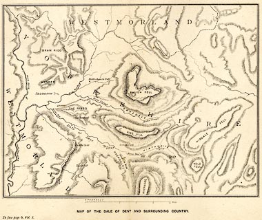
Map of the Vale of Dent and Surrounding Country, Dent,
Yorkshire, scale about 1.5 miles to 1 inch, published by
Cambridge University Press, Cambridge, Cambridgeshire, 1890.
Between pp.6-7 vol.1 of The Life and Letters of the Reverend Adam Sedgwick. |
||

|
Clark and Hughes 1890 map | |
| inscription:- |
printed with scale line
Miles |
|
| scale line:- | 4+1 miles = 74.8 mm | |
| wxh, page:- | 27x22cm | |
| wxh, image:- | 226x170mm | |
| scale:- | 1 to 110000 ? (1 to 107576 to from scale line) | |