 Seale 1761

|

|
|
|
item:- private collection (174) image:- © see bottom of page |
click to enlarge |
|
|
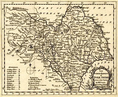
Map, uncoloured engraving, The North Riding of York
Shire, scale about 8 miles to 1 inch, by R W Seale,
published by John Hinton, Newgate Street, London, 1761.
Included in The Universal Magazine of Knowledge and Pleasure. |
||

|
Seale 1761 | |
| map feature:- | baroque cartouche & compass rose & up is N & scale line & lat and long scales & table of symbols & sea plain & coast form lines & rivers & forests & relief & hillocks & parks & county & hundreds & table of hundreds & settlements & roads | |
| inscription:- |
printed title cartouche, lower right
THE / NORTH RIDING / of / YORK SHIRE. / from a late Survey / by R. W. Seale. / Univers. Mag. J. Hinton, / Newgate Str. |
|
| inscription:- |
printed above scale line
English Statute Miles |
|
| scale line:- | 10 miles = 30.8 mm | |
| scale:- | 1 to 520000 ? (1 to 522514 from scale line) | |
| wxh, sheet:- | 21.5x17.5cm | |
| wxh, map:- | 212x172mm | |