 Wallace 1890 map

|

|
|
|
item:- private collection (160_1) image:- © see bottom of page |
click to enlarge |
|
|
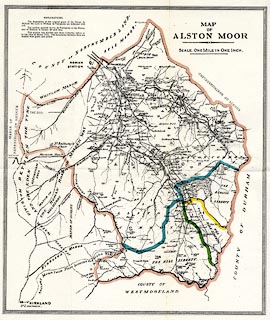
Map, colour lithograph, Map of Alston Moor, scale about 1
inch to 1 mile, by William Wallace, published by Mawson,
Swan and Morgan, Grey Street, Newcastle upon Tyne,
Northumberland, 1890
Before the frontispiece of Alston Moor, its Pastoral People, its Mines and Miners. |
||

|
Wallace 1890 map | |
| map feature:- | up is N & rivers & relief & spot heights & woods & county & settlements & roads & railways | |
| inscription:- |
printed upper right
MAP / OF / ALSTON MOOR / SCALE. ONE MILE IN ONE INCH. |
|
| wxh, sheet:- | 31.5x37cm | |
| wxh, map:- | 281x329mm | |
| scale:- | 1 to 63000 ? (1 to 63360 nominal) | |