 Cruchley 1856

|

|
|
|
item:- JandMN (334) image:- © see bottom of page |
click to enlarge |
|
|
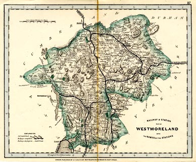
Railway map, colour printed, Railway and Station Map of
Westmoreland, scale about 5 miles to 1 inch, by G F
Cruchley, 81 Fleet Street, London, 1860s?
Plate 37. This is a reduced version of the map with a simpler title. The railways shown are - Lancaster and Carlisle Railway, open 1846; Kendal and Windermere Railway, open 1846; Ulverstone and Lancaster Railway, open 1857; Low Gill and Ingleton branch railway, open about 1859; South Durham and Lancashire Union Railway, open 1861; and Eden Valley Railway, open 1862. |
||

|
Cruchley 1856 | |
| map feature:- | table of symbols & up is N & scale line & lat and long scales (rectangular projection, West from London) & coast form lines & rivers & lakes & relief & hill hachuring & forests & parks & county & settlements & roads & canals & railways | |
| inscription:- |
printed lower right
RAILWAY & STATION / MAP OF / WESTMORELAND / WITH / THE NAMES OF THE STATIONS |
|
| inscription:- |
printed bottom
LONDON. PUBLISHED BY G.F. CRUCHLEY, MAP-SELLER & GLOBE MAKER 81 FLEET STREET. |
|
| inscription:- |
printed above the scale line
British Statute Miles 69 1/2 to a Degree |
|
| scale line:- | 10 miles = 50.8 mm | |
| scale:- | 1 to 320000 ? (1 to 316800 from scale line) | |
| wxh, sheet:- | 29x23cm | |
| wxh, map:- | 267x216mm | |