 Smith 1752

|

|
|
|
item:- private collection (130_1) image:- © see bottom of page |
click to enlarge |
|
|
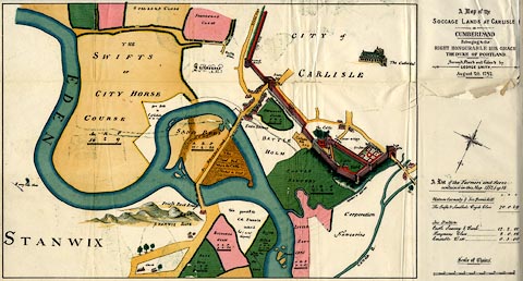
Map, estate plan, reproduction of A Map of the Soccage
Lands at Carlisle in Cumberland, by George Smith, Carlisle,
Cumberland, 1752, reproduction scale about 16.5 inches to 1
mile, published by Charles Thurnam and Sons, Carlisle,
Cumberland, Titus Wilson, Kendal, Westmorland, and Elliot
Stock, London, 1894.
Reproduced from a copy used for a trial between the Corporation of Carlisle and the Duke of Devonshire about land rights, late 19th century. Tipped in oppposite p.1 of The Royal Charters of the City of Carlisle, edited by R S Ferguson. |
||

|
Smith 1752 | |
| map feature:- | folded (5x2) & vignettes (Carlisle Cathedral) & compass rose & up is SE & scale line & rivers & relief & hillocks & woods & settlements & roads & field names | |
| inscription:- |
printed upper right
A Map of the / SOCCAGE LANDS AT CARLISLE / IN / CUMBERLAND / Belonging to the / RIGHT HONOURABLE HIS GRACE / THE DUKE OF PORTLAND. / Survey'd, Plan'd and Colour'd by / GEORGE SMITH, / August 26, 1752. |
|
| inscription:- |
printed with scale line
Scale of Chains. |
|
| scale line:- | 15 chains = 79.7 mm | |
| wxh, sheet:- | 52x30cm | |
| wxh, map:- | 407x272mm | |
| scale:- | 1 to 3800 ? (1 to 3786 from scale line) | |