 Bartholomew 1875-88

|

|
|
|
item:- JandMN (316) image:- © see bottom of page |
click to enlarge |
|
|
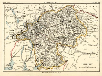
Map, colour lithograph, Westmorland, scale about 6 miles
to 1 inch, by John Bartholomew, published by W and A K
Johnston, Edinburgh, 1875-88.
Plate 12 in vol.24 of Encyclopaedia Britannica 9th edn. |
||

|
Bartholomew 1875-88 | |
| map feature:- | up is N & scale line & lat and long scales & sea tinted & coast line & rivers & lakes & relief & hill hachuring & spot heights & forests & parks & county & settlements & roads & railways & canals | |
| inscription:- |
printed top
VOL.XXIV WESTMORLAND. PLATE XII |
|
| inscription:- |
printed bottom left, centre
J. Bartholomew / ENCYCLOPAEDIA BRITANNICA NINTH EDITION |
|
| inscription:- |
printed with scale line
Scale of Miles |
|
| scale line:- | 10 miles = 41.0 mm | |
| wxh, sheet:- | 27.5x20.5cm | |
| wxh, map:- | 244x172mm | |
| scale:- | 1 to 390000 ? (1 to 392523 from scale line assuming a statute mile) | |