 Panorama from Castle Head, Keswick

|

|
|
|
item:- JandMN (305_2) image:- © see bottom of page |
click to enlarge |
|
|
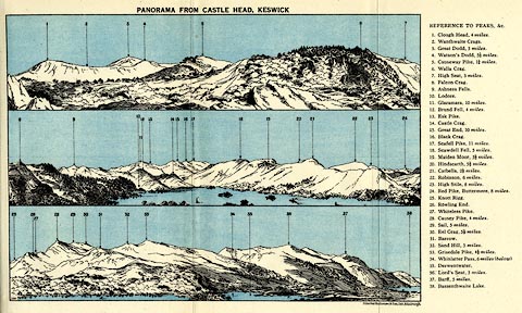
Print, lithograph, Panorama from Castle Head, Keswick,
engraved by John Bartholomew and Co, Edinburgh, published by
Ward, Lock and Co, Warwick House, Salisbury Square, London,
1930s.
Folded and tipped in opposite p.164 of Baddeleys' Guide to the English Lake District. The view is presented in 3 sections, the tops numbered, referring to a list at the side. |
||
| source type:- | Baddeley 1930s | |
| inscription:- |
printed top
PANORAMA FROM CASTLE HEAD, KESWICK |
|
| inscription:- |
printed right
REFERENCES TO PEAKS, &C. / 1. Clough Head, 4 miles. 2. Wanthwaite Crags. 3. Great Dodd, 5 miles. 4. Watson's Dodd, 4 1/2 miles. 5. Causeway Pike, 1 1/4 miles. 6. Walla Crag. 7. High Seat, 3 miles. 8. Falcon Crag. 9. Ashness Fells. 10. Lodore. 11. Glaramara, 10 miles. 12. Brund Fell, 4 miles. 13. Esk Pike. 14. Castle Crag. 15. Great End, 10 miles. 16. Black Crag. 17. Scafell Pike, 11 miles. 18. Scawdell Fell, 5 miles. 19. Maiden Moor, 3 1/2 miles. 20. Hindscarth, 5 1/2 miles. 21. Catbells, 2 1/2 miles. 22. Robinson, 6 miles. 23. High Stile, 8 miles. 24. Red Pike, Buttermere, 8 miles. 25. Knott Rigg. 26. Rowling End. 27. Whiteless Pike. 28. Causey Pike, 4 miles. 29. Sail, 5 miles. 30. Eel Crag, 5 1/2 miles. 31. Barrow. 32. Sand Hill, 5 miles. 33. Grisedale Pike, 4 1/2 miles. 34. Whinlatter Pass, 6 miles (below) 35. Derwentwater. 36. Lord's Seat, 5 miles. 37. Barff, 5 miles. 38. Bassenthwaite Lake. |
|
| wxh, sheet:- | 25.5x16cm | |
| wxh, image:- | 191x134mm | |