 Panorama of Fells, etc, from Orrest Head

|

|
|
|
item:- JandMN (305_1) image:- © see bottom of page |
click to enlarge |
|
|
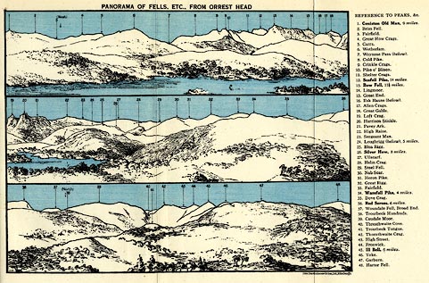
Print, lithograph, Panorama of Fells, etc, from Orrest
Head, engraved by John Bartholomew and Co, Edinburgh,
published by Ward, Lock and Co, Warwick House, Salisbury
Square, London, 1930s.
Folded and tipped in opposite p.62 of Baddeleys' Guide to the English Lake District. The view is presented in 3 sections, the tops numbered, referring to a list at the side. |
||
| source type:- | Baddeley 1930s | |
| inscription:- |
printed top
PANORAMA OF FELLS, ETC., FROM ORREST HEAD |
|
| inscription:- |
printed right
REFERENCES TO PEAKS, &C. / 1. Coniston Old Man, 9 miles. 2. Brim Fell. 3. Fairfield. 4. Great How Crags. 5. Carrs. 6. Wetherlam. 7. Wrynose Pass (below). 8. Cold Pike. 9. Crinkle Crags. 10. Pike o' Blisco. 11. Shelter Crags. 12. Scafell Pike, 14 miles. 15. Bow Fell, 11 1/2 miles. 16. Esk Hause (below). 17. Allen Crags. 18. Great Gable. 19. Loft Crag. 20. Harrison Stickle. 21. Pavey Ark. 22. High Raise. 23. Sergeant Man. 24. Loughrigg (below), 5 miles. 25. Blea Rigg. 26. Silver How, 8 miles. 27. Ullscarf. 28. Helm Crag. 29. Steel Fell. 30. Nab Scar. 31. Heron Pike. 32. Great Rigg. 33. Fairfield. 34. Wansfell Pike, 4 miles. 35. Dove Crag. 36. Red Screes, 6 miles. 37. Woundale Fell, Broad End. 38. Troutbeck Hundreds. 39. Caudale Moor. 40. Thresthwaite Cove. 41. Troutbeck Tongue. 42. Thornthwaite Crag. 43. High Street. 44. Froswick. 45. Ill Bell, 6 miles. 46. Yoke. 47. Garburn. 48. Harter Fell. |
|
| wxh, sheet:- | 24.5x16cm | |
| wxh, image:- | 189x143mm | |