 Prior 1850s map

|

|
|
|
item:- Kendal Library (18_2) image:- © see bottom of page |
click to enlarge |
|
|
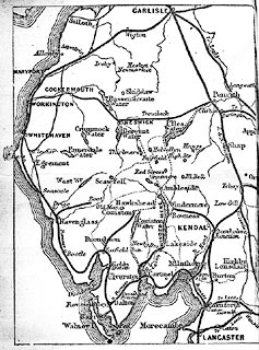
Railway map, the Lakes, drawn for Herman Prior by John
Bartholomew, Edinburgh, published by John Garnett,
Windermere, Westmorland and Simpkin, Marshall and Co,
London, 1885.
On page 2 of a Guide to the Lake District of England, by Herman Prior, 5th edn 1885. |
||

|
Prior 1850s map | |
| map feature:- | up is N & sea plain & coast shaded & rivers & lakes & county (boundaries, no labels) & settlements & railways | |