 Gibson 1760

|

|
|
|
item:- Armitt Library : Gents Mag 1760.1 image:- © see bottom of page |
click to enlarge |
|
|
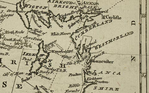
Chart, uncoloured engraving, A Correct Chart of the Irish
Sea, scale about 43 miles to 1 inch, engraved by J Gibson,
published by the Gentleman's Magazine, 1760.
Folded and tipped in opposite p.108 in the Gentleman's Magazine vol.30, 1760. There is descriptive text pp.107-112. |
||

|
Gibson 1760 | |
| map feature:- | folded & plain cartouche & compass rose & up is N & rhumb lines & scale line & lat and long scales & sea plain & coast shaded (inland) & rivers & county & settlements | |
| inscription:- |
printed plain cartouche, lower left
A Correct Chart of the / IRISH SEA, &C. / exhibiting a View / of the / several Islands & Bays / lately touch'd at by / M. THUROT, / in his Attempt upon / IRELAND |
|
| inscription:- |
printed lower right
J. Gibson sculpt. |
|
| inscription:- |
printed with scale line
A Scale of Miles 60 to a Degree |
|
| scale line:- | 100 miles = 58.9 mm | |
| wxh, sheet:- | 21x25.5cm | |
| wxh, map:- | 181x233mm (approx) | |
| scale:- | 1 to 2700000 ? (1 to 2732332 from scale line) | |