 Clarke 1787 map

|

|
|
|
item:- private collection (169) image:- © see bottom of page |
click to enlarge |
|

|
menu with map squares and placename index | |
|
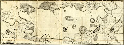
Map, uncoloured engraving, Map of Derwentwater and its
Environs, scale about 13 ins to 1 mile, by James Clarke,
engraved by S J Neele, published by James Clarke, Penrith,
Cumberland and in London etc, 1787.
Plate 6 in A Survey of the Lakes of Cumberland, Westmorland, and Lancashire. The map is printed on two sheets of paper which were pasted together on the binding tab, each sheet folded separately into the book. |
||
|
|
Clarke 1787 map | |
| map feature:- | floral cartouche & compass rose & up is NW & scale line & lat and long grid (?) & rivers & lakes (form lines on shore) & woods & trees & county & settlements & roads | |
| inscription:- |
printed title cartouche, lower left
MAP OF / DERWENTWATER / and its / ENVIRONS. / Surveyed by JAMES CLARKE. illustrated with masonic symbols |
|
| inscription:- |
printed above title cartouche
Engraved by S. J. Neele / No 352 Strand London |
|
| inscription:- |
printed upper right
Plate 6 |
|
| inscription:- |
printed bottom
Published Feby. 10th. 1787, by James Clarke, Penrith. |
|
| inscription:- |
printed with scale line
A Scale of Chains |
|
| scale line:- | 35 chains = 142.6 mm | |
| scale:- | 1 to 5000 ? (1 to 4938 from scale line) | |
| wxh, map:- | 1315x473mm | |