 Everybody's 1955

|

|
|
|
item:- JandMN (101) image:- © see bottom of page |
click to enlarge |
|
|
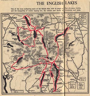
Map, The English Lakes, in a guide booklet, Everybody's
Pictorial Touring Maps, published by Everybody's magazine,
1955.
The booklet was published in a series of 4 weekly pull-out supplements, 12 to 28 March 1955, which were to be folded and assembled; compiled with the assistance of The Autocar and The Motor Cycle. The Lakes are pp.4-6, with an area map and a detail map west of Ambleside, and three illustrations by Peter Jackson. |
||

|
Everybody's 1955 | |
| map feature:- | up is N & coast tinted & rivers & lakes & relief & contours & layer colouring & spot heights & settlements & roads | |
| inscription:- |
printed title page (p.1 12 March 1955)
Everybody's / PICTORIAL / TOURING MAPS / for / MOTORISTS, CYCLISTS / and those who walk the Queen's Highway / Compiled with the expert / assistance of 'The Autocar' / and 'The Motor Cycle' / with specially commissioned drawings by Peter Jackson / ... |
|
| inscription:- |
printed pp.4-5, map caption
THE ENGLISH LAKES / One of the most enchanting parts of the British Isles, with its magic of far-distant hills / and the tranquillity of waters lapping low, the colours and forms of mountains and rocks |
|
| wxh, map:- | 20.5x19cm | |