 Housman 1800 map 2

|

|
|
|
item:- JandMN (233_2) image:- © see bottom of page |
click to enlarge |
|
|
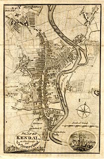
Street map, uncoloured engraving, Plan of Kendal, scale
about 6 inches to 1 mile, engraved by James Lowes, 1798
published by F Jollie, Carlisle, Cumberland, 1800.
Taken from a guide book, A Descriptive Tour, and Guide to the Lakes, Caves, Mountains, ... by John Housman, 1800, 5th edn 1812. |
||

|
Housman 1800 map 2 | |
| map feature:- | oval cartouche & compass rose & up is N (N by W) & scale line & rivers & settlements & roads & vignettes | |
| inscription:- |
printed oval cartouche, lower left
A / PLAN OF / KENDAL, / in the County / OF / Westmoreland. / J. Lowes Sculp 1798. |
|
| inscription:- |
printed with scale line
Scale of Yards |
|
| wxh, sheet:- | 14.5x20.5cm | |
| wxh, map:- | 118x181mm | |
| scale:- | 1 to 11000 ? (1 to 10707 from scale line) | |