 Stanford 1907

|

|
|
|
item:- JandMN (193_1) image:- © see bottom of page |
click to enlarge |
|
|
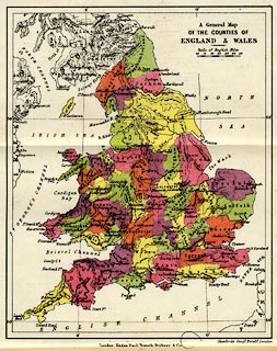
Map, colour lithograph, General Map of the Counties of
England and Wales, scale about 57 miles to 1 inch, by
Stanford's Geographical Establishment, London, published by
Kegan Paul, Trench, Trubner and Co, Broadway House, 68-74
Carter Lane, London, edn 1930.
Frontispiece in The Counties of England, in the Ambleside Geography Books series, by Charlotte M Mason. |
||

|
Stanford 1907 | |
| map feature:- | up is N & scale line & lat and long scales (trapezoidal projection) & lat and long grid (4 degree intervals) & sea plain & coast line & rivers & relief & hill hachuring & county & settlements | |
| inscription:- |
printed upper right
A General Map / OF THE COUNTIES OF / ENGLAND & WALES |
|
| inscription:- |
printed bottom right, centre
Stanford's Geogl. Estabt. London / London : Kegan Paul, Trench, Trubner & Co. |
|
| inscription:- |
printed with scale line
Scale of English Miles |
|
| scale line:- | 50 miles = 22.1 mm | |
| wxh, sheet:- | 18.5x20cm | |
| wxh, map:- | 137x171mm | |
| scale:- | 1 to 3600000 ? (1 to 3641050 from scale line) | |