 Collingwood 1899 map 1

|

|
|
|
item:- JandMN (190_1) image:- © see bottom of page |
click to enlarge |
|
|
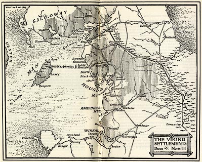
Map, uncoloured lithograph? The Viking Settlements, scale
roughly 21 miles to 1 inch, by W G Collingwood, published
for the Cumberland and Westmorland Antiquarian and
Archaeological Society, by Titus Wilson, Kendal,
Westmorland, 1899.
The maps shows areas of norse and danish Viking settlement in the north of England, parts of southern Scotland and the Isle of Man. Included as pp.292-293 in Notes on the Early Sulptured Crosses, Shrines and Monuments in the Present Diocese of Carisle, by Rev William Slater Calverley, edited by W G Collingwood. The reverse is text pages 291 and 294. |
||

|
Collingwood 1899 map 1 | |
| inscription:- |
printed title cartouche, lower right
THE VIKING / SETTLEMENTS / Danes [symbol] Norse [symbol] |
|
| wxh, sheet:- | 28x22cm | |
| wxh, map:- | 238x194mm | |
| scale:- | 1 to 1400000 ? (estimate) | |