 Cruchley 1856

|

|
|
|
item:- JandMN (191_1) image:- © see bottom of page |
click to enlarge |
|
|
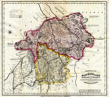
Map, coloured lithograph, Cruchley's County Map of
Westmoreland, scale about 2.5 miles to 1 inch, by George F
Cruchley, London, 1856 and 1885, published by T Bulmer and
Co, Manchester and T Snape, Preston, Lancashire, 1885.
Included in Bulmer's History, Topography and Directory of Westmoreland. There are geological comments around the edge of the map. |
||

|
Cruchley 1856 | |
| map feature:- | compass rose & up is N & scale line & lat and long scales & table of symbols & coast form lines & rivers & lakes & relief & hill hachuring & woods (?) & parks & county & electoral data & settlements & roads & canals & railways & electric telegraph & geology | |
| inscription:- |
printed lower right
CRUCHLEY'S / COUNTY MAP OF / WESTMORELAND / Showing all the / RAILWAYS & NAMES OF STATIONS, / ALSO THE / VILLAGES, TURNPIKE ROADS, GENTLEMENS SEATS &c. &c. / Improved from the / ORDNANCE SURVEYS |
|
| inscription:- |
printed bottom
PREPARED FOR T. BULMER & CO.'S HISTORY & DIRECTORY OF WESTMORELAND. |
|
| inscription:- |
printed with scale line
SCALE / Miles |
|
| scale line:- | 8 miles = 86.0 mm | |
| scale:- | 1 to 150000 ? (1 to 149706 from scale line) | |
| wxh, folded:- | 13x21cm | |
| wxh, sheet:- | 58x50.5cm | |
| wxh, map:- | 548x487mm | |