 Garnett 1850s-60s B

|

|
|
|
item:- JandMN (149_1) image:- © see bottom of page |
click to enlarge |
|
|
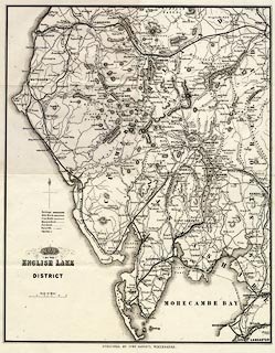
Map, uncoloured engraving, Map of the English Lake
District, scale about 3.5 miles to 1 inch, published by J
Garnett, Windermere, Westmorland, 1850s-60s?
Included in a pocket at the back of A Guide to the English Lake District, by a Cambridge Man, published by John Garnett and by Simpkin, Marshall and Co, London. The railways shown are, I think - Lancaster and Carlisle Railway; Kendal and Windermere Railway; Ulverstone and Lancaster Railway; Cockermouth, Keswiccck and Penrith Railway; Cockermouth and Workington Railway; Conishead Priory branch railway; Coniston Railway; Furness Railway; Lakeside branch railway; Ravenglass and Eskdale Railway (old); Whitehaven and Furness Junction Railway; Whitehaven, Cleator and Egremont Railway; and Whitehaven Junction Railway. |
||

|
Garnett 1850s-60s B | |
| map feature:- | folded (2x4) & north point & up is N & scale line & table of symbols & sea plain & coast form lines & rivers & lakes & relief & hill hachuring & forests & parks & county & settlements & roads & railways & canals | |
| inscription:- |
printed lower left
MAP / of the / ENGLISH LAKE / DISTRICT |
|
| inscription:- |
printed bottom
PUBLISHED BY JOHN GARNETT, WINDERMERE. |
|
| inscription:- |
printed above scale line
Scale of Miles |
|
| scale line:- | 5 miles = 37.1 mm | |
| wxh, sheet:- | 29.5x36.5cm | |
| wxh, map:- | 270x339mm | |
| scale:- | 1 to 220000 ? (1 to 216893 from scale line) | |