 Garnett 1850s-60s B

|

|
|
|
item:- Dove Cottage : 2005.18.1.2 image:- © see bottom of page |
click to enlarge |
|
|
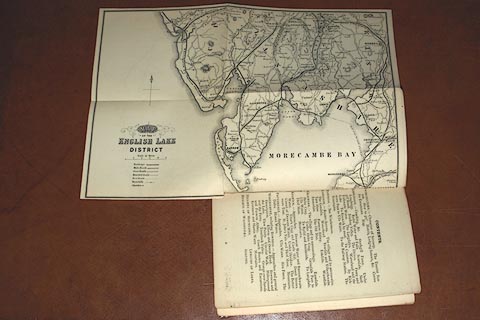
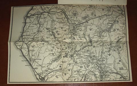
Map, uncoloured engraving, two sided, Map of the English
Lake District, scale about 3.5 miles to 1 inch, published by
J Garnett, Windermere, Westmorland, 1850s-60s?
Opposite p.2 in The Lake District of England. The railways shown are, I think - Lancaster and Carlisle Railway; Kendal and Windermere Railway; Ulverstone and Lancaster Railway; Cockermouth, Keswick and Penrith Railway; Cockermouth and Workington Railway; Conishead Priory branch railway; Coniston Railway; Furness Railway; Lakeside branch railway; Ravenglass and Eskdale Railway (old); Whitehaven and Furness Junction Railway; Whitehaven, Cleator and Egremont Railway; and Whitehaven Junction Railway. p.3 of the guide book says 'Map. - The readers of this short Guide should understand that the constant use of the Map is expected to economise the use of many words.' |
||

|
Garnett 1850s-60s B | |
| map feature:- | two sided & folded (2x2) & north point & up is N & scale line & table of symbols & sea plain & coast form lines & rivers & lakes & relief & hill hachuring & forests & parks & county & settlements & roads & railways & canals | |
| inscription:- |
printed lower left
MAP / of the / ENGLISH LAKE / DISTRICT |
|
| inscription:- |
printed above scale line
Scale of Miles |
|
| scale line:- | 5 miles = 37 mm | |
| wxh, sheet:- | 28x19cm | |
| wxh, map:- | 27.5x37cm | |
| scale:- | 1 to 220000 ? (1 to 217479 from scale line) | |
|
||