 Smith 1751

|

|
|
|
item:- Armitt Library : Gents Mag 1751.1 image:- © see bottom of page |
click to enlarge |
|
|
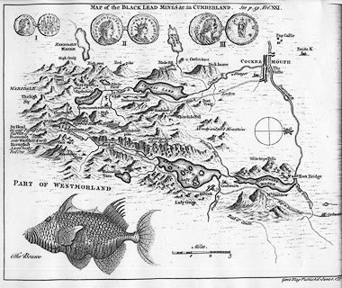
Map, uncoloured engraving, Map of the Black Lead Mines in
Cumberland, and area, scale about 2 miles to 1 inch, by
George Smith, published by the Gentleman's Magazine, 1751.
The map includes Cockermouth, Keswick, Borrowdale etc, south to Seathwaite. The map was published in June 1751 to accompany an article by GS, in the issue for February 1751, vol.21 opposite p.51. |
||

|
Smith 1751 | |
| map feature:- | compass rose (minimal) & up is W & scale line & rivers & lakes & relief & hillocks & woods & settlements & roads | |
| inscription:- |
printed upper centre
MAP of the BLACK LEAD MINES &c. in CUMBERLAND See p.51. Vol.XXI. |
|
| inscription:- |
printed bottom right
Gent. Mag. Publish'd June 1. 1751. |
|
| inscription:- |
printed with scale line
Miles |
|
| scale line:- | 3 miles = 40.6 mm | |
| wxh, sheet:- | 25.5x21cm (approx) | |
| wxh, map:- | 241x196mm | |
| scale:- | 1 to 120000 ? (1 to 118917 from scale line) | |