 Paterson 1785

|

|
|
|
item:- Armitt Library : ALMC2008.14.116 image:- © see bottom of page |
click to enlarge |
|
|
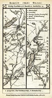
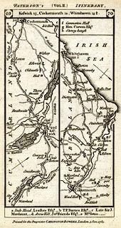
Road strip map, uncoloured engraving, two sided, parts of
Kirkby Lonsdale to Whitehaven, scale about 3 miles to 1
inch, by Captain Daniel Paterson, published by Carington
Bowles, 69 St Paul's Churchyard, London, 1785.
Included in Paterson's British Itinerary, vol.2. Plate 67/68 - from Kirkby Lonsdale, through Kendal, Ambleside, Westmorland; into Cumberland. Plate 69/70 - from about Wythburn, through Keswick, Cockermouth, past Workington, to Whitehaven, Cumberland. |
||

|
Paterson 1785 | |
| map feature:- | north point & up is destination & sea plain & coast form lines & rivers & lakes & parks & county & settlements & roads & road distances & distances from London | |
| inscription:- |
pl.67/68: printed top
DIRECT (VOL.II.) ROADS. |
|
| inscription:- |
pl.67/68: printed cartouche at top
67 / Kirkby Lonsdale 17 1/2, Kendal 12, Ambleside 14. / 68 |
|
| inscription:- |
pl.69/70: printed top
PATERSON'S (VOL.II.) ITINERARY. |
|
| inscription:- |
pl.69/70: printed cartouche at top
69 / Keswick 15, Cockermouth 12, Whitehave 13 1/2. / 70 |
|
| inscription:- |
printed bottom
Printed for the Proprietor CARINGTON BOWLES, London, 3 Jan. 1785. |
|
| wxh, sheet:- | 11.5x18.5cm | |
| wxh, map:- | 87x161mm | |
| scale:- | 1 to 190000 ? (guess) | |
|
||