 Ogilby 1675

|

|
|
|
item:- Armitt Library : ALMC2008.14.103 image:- © see bottom of page |
click to enlarge |
|
|
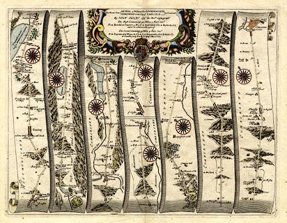
Strip map, road map, uncoloured engraving, the Road from
Kendal to Cockermouth, and the Road from Egremond to
Carlisle, scale about 1 inch to 1 mile, by John Ogilby,
London, 1675.
Plate 96 in Britannia - from Kendal through Stanley ie Stavlely, Ambleside, Westmorland; then Keswick to Cockermouth, Cumberland; AND from Egremond ie Egremont through Cockermouth to Carlisle, Cumberland. The accompanying itinerary is recorded separately. |
||

|
Ogilby 1675 | |
| map feature:- | scroll cartouche & compass rose & up is destination & rivers & lakes & relief & hillocks & parks & county & settlements & roads & road distances & distances from start | |
| inscription:- |
printed title cartouche, top centre
The Roads from KENDAL in Westmerld. to COCKERMOUTH / EGREMOND to the City of CARLISLE in Cumberld. By JOHN OGILBY his Maties. Coemographr. The First Containing 43. Miles 7. Furl : ... The Second Containing 39. Miles 4. Furl. ... table of distances; coat of arms |
|
| scale:- | 1 to 63360 ? (nominal) | |
| wxh, sheet:- | 51x42cm | |
| wxh, plate:- | 450x346mm | |
| wxh, map:- | 445x340mm | |