 Hughes 1868

|

|
|
|
item:- Armitt Library : ALMC2008.14.82 image:- © see bottom of page |
click to enlarge |
|
|
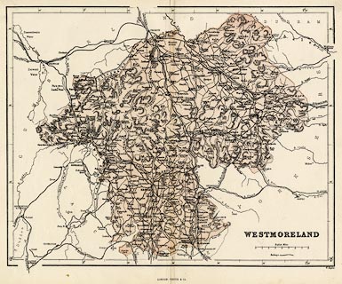
Maps, colour lithograph, Westmoreland ie Westmorland,
scale about 4 miles to 1 inch, by William Hughes, published
by James S Virtue and Co, City Road and Ivy Lane, London,
1868, edn 1886?
|
||

|
Hughes 1868 | |
| map feature:- | table of symbols (rather little) & up is N & scale line & lat and long scales & coast line & rivers & lakes & relief & hill hachuring & county & settlements & roads & canals & railways | |
| inscription:- |
printed lower right
WESTMORELAND |
|
| inscription:- |
printed bottom centre and right
LONDON : JAMES S. VIRTUE. / W. Hughes |
|
| inscription:- |
printed above scale line
English Miles |
|
| scale line:- | 8 miles = 48.2 mm | |
| longitude, Kendal:- | 2d 45m W (about) | |
| scale:- | 1 to 270000 ? (1 to 267111 from scale line) | |
| wxh, sheet:- | 33.5x27cm | |
| wxh, map:- | 298x238mm | |