 Seller 1694

|

|
|
|
item:- Armitt Library : ALMC2008.14.34 image:- © see bottom of page |
click to enlarge |
|
|
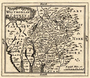
Map, uncoloured engraving, Westmorland, scale about 8
miles to 1 inch, by John Seller, 1694-1703.
From Anglia Contracta or A Description of the Kingdom of England and Principality of Wales; the reverse is plain. |
||

|
Seller 1694 | |
| map feature:- | wreath cartouche & labelled borders & up is N & scale line & sea plain & coast shaded & rivers & lakes & relief & hillocks & forests & county & settlements & roads | |
| inscription:- |
printed title cartouche, upper left
WESTMORLAND / COUNTY |
|
| scale line:- | 10 miles = 31.3 mm | |
| scale:- | 1 to 510000 ? (1 to 514167 from scale line) | |
| wxh, sheet:- | 20x19cm | |
| wxh, plate:- | 145x122mm | |
| wxh, map:- | 142x120mm | |