 Buttermere and Crommock Water

|

|
|
|
item:- private collection (112) image:- © see bottom of page |
click to enlarge |
|
|
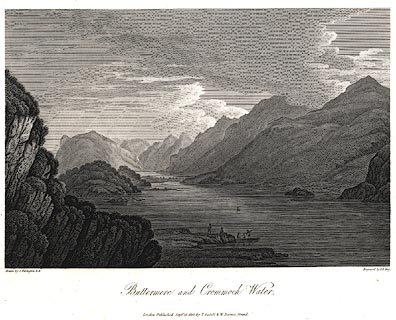
Print, uncoloured engraving, Buttermere and Crommock
Water, Buttermere, Cumberland, drawn by Joseph Farington,
engraved by F R Hay, published by T Cadell and W Davies,
Strand, London, 1815.
Plate 28 in The Lakes of Lancashire, Westmorland, and Cumberland. The accompanying text is by Thomas Hartwell Horne:- BUTTERMERE AND CROMMOCK WATER. THE Lake of Buttermere is of an oblong form, not exceeding half a mile in breadth; its length is something more than a mile and a half, and it derives its supply of water from a river that flows through Gatesgarth-Dale. Its western shores are hemmed in by a long range of rugged mountains, which rise abruptly from the margin of the water with dark and gloomy aspects, and are known to the shepherds, by whom their craggy steeps are chiefly traversed, by the names of Hay-Cock, High-Crag, High-Stile, and Red-Pike. The blue rag-stone, of which these dark mountains are mostly composed, is not porous, and absorbs but little water; a circumstance that accounts for the number and variety of the little waterfalls, which in different parts are seen pouring down their steep sides. The eastern shores rise more gently, are partially wooded, and admit of cultivation at a short distance from the Lake; the north end is skirted by the verdant vale of Buttermere, so celebrated by tourists; and the southern extremity is bounded by Honister Crag, which is delineated in the folowing engraving. From this steep, numerous torrents are continually pouring down their foaming waters into the Lake: one of these roaring cataracts appears in the back-ground of the present view. It is called Scale-force, and is two hundred feet perpendicular: the steep on both sides is covered with moss, fern, ash, and oak, which are all fed by the constant spray, and flourish in indescribable verdure. The delicacy of the effect is heightened by being in a narrow chasm, a hundred yards in the rock, before it rushes into the lower fall, from the point of which the best view is to be obtained. CROMMOCK, or CRUMMOCK WATER, which is seen in the fore-ground of the present view, is separated from Buttermere by a fine level and luxuriant vale. The view form the middle of Crummock Water is singularly grand: the mountains on each side, rise immediately from the water, and consequently appear higher as well as more precipitous than some others in its neighbourhood. Some of these are naked, other wooded to their bases; some are verdant, and some rocky and heathy. This lake is nearly four miles long, and about half a mile broad. |
||
| source type:- | Farington 1816 (plate 28) | |
| inscription:- |
printed bottom left, right, centre
Drawn by J. Farington. / Engraved by F. R. Hay. / Buttermere and Crommock Water. / London, Published Septr. 15, 1815, by T. Cadell & W. Davies, Strand. |
|
| wxh, sheet:- | 37x28cm | |
| wxh, image:- | 228x152mm | |