 Wetherall Priory

|

|
|
|
item:- Dove Cottage : Lowther.69 image:- © see bottom of page |
click to enlarge |
|
|
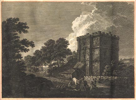
Print, engraving, Wetherall Priory, probably drawn by
Thomas Hearne, engraved by William Byrne, published by T
Hearne and W Byrne, London, 1786.
Plate ?from the Antiquities of Great Britain, published 1786-1807. Pasted in the Lowther scrapbook, vol.3; between pp.328-329; with descriptive text:- WETHERALL PRIORY, / Is situated on the banks of the river Eden, in the county of Cumberland. Here Ranulph de Meschines, Earl of Chester, the great northern grantee of lands in Cumberland, founded a Cell, anno 1088, for a Prior and eight Benedictine Monks, and gave the same, together with the Church, the Mill, the Fishery, Wood, and Chapel of Warthwick &c. to the Abbey of St. Mary at York. He also granted to them the water of Eden, towards Corby, whereby their fish-pool was strengthened and secured. / William Rufus, by his charter, confirmed to the Abbey of St. Mary at York, the Cell of St. Constantine of Wetherall, and the Manor there, with the Chapel of Warthwick, and the Pond and Fishery, and Mill, which they had by the gift of Ranulph de Meschines, the founder. / Henry the I. Richard the I. and several succeeding Kings, confirmed all the donations which had been made to this Priory, and the religious continued to flourish by the benefactions of various pious people, till the dissolution; when, on the 20th of October, 1539, Ralph Hartley the Prior, and the Convent surrendered the Priory into the King's Hands. / On the 6th of May, in the thirty-third year of Henry the VIII. the King by his charter, granted to the Dean and Chapter of Carlisle, all that the scite of the Priory or Cell of Wetherall, with the Church, Steeple, Church-yard, and all other lands and possessions in and about the same; together with the Manor of Wetherall, and sundry other estates belonging to the said late dissolved Priory in Cumberland and other Counties. / The Dean and Chapter of Carlisle continued in the possession of them , till the year 1650, when Oliver Cromwell's commissioners for the sale of dean-and-chapter lands, sold the Manor of Wetherall, and all the late Dean and Chapter's possessions within the side Manor, to Richard Bancks of Cockermouth, gent. for the sum of L1044 5 1 1/2; but on the restoration, the Dean and Chapter came again into possession, in which they have ever since continued. / Near this Priory are three remarkable Cells cut in the solid stone, communicating with each other by means of a gallery in front; these excavations are about midway, from the bottom to the summit of the rocks, rising 300 feet perpendicular above the river Eden, and are only accessible by means of ladders. They are said to have been made as a place of security for the Monks of this Priory, who were frequently obliged to retreat thither in times of danger, particularly during the incursions of the Scots. / To the right of the Priory, in the Print, is seen Corby-Castle, situated opposite to Wetherall, on the east side of the River Eden. This Castle anciently belonged to Andrew de Harcla, Earl of Carlisle; it afterwards passed to the families of Salkeld and Blenkinsop, and is now the seat of Philip Howard, Esq. a younger branch of the noble House of Carlisle. / This View was taken in 1777. / No.XIV. The print's title and imprint are cut off. |
||
| source type:- | Hearne and Byrne 1786 (?) | |
| wxh:- | 2254x185mm | |
|
from:- Scrapbook, 4 volumes, History of Westmorland and Cumberland Illustrated, of descriptive texts, maps, and prints of views and coats of arms, for Westmorland and Cumberland, assembled by a member of the Lowther Family, late 18th early 19th century. The volumes are quarter bound, with marbled paper on the covers; each has a bookplate inside the front cover. The pages cut from various sources are nicely mounted, two sided pieces set neatly in a window in the scrapbook page. The main content is the whole of the two volumes of The History and Antiquities of the Counties of Westmorland and Cumberland, by Joseph Nicolson and Richard Burn, published London, 1777. Nicolson and Burn volume 1 is in scrapbook volumes 1 and 2, volume 2 in scrapbook volumes 3 and 4. Maps and prints are interspersed to make an illustrated version of the history. Some of the sources of maps and prints have been recognised:- Maps - coast of Cumberland etc by Andrew Dury, 1764; Westmorland and Cumberland by Richard Blome, 1673; sheets from Britannia Depicta, Emanuel Bowen, 1720; Cumberland by John Speed, Henry Overton edn 1695; Cumberland by John Cary 1787. Prints from the Set of prints, 20 engravings, Views of the Lakes etc in Cumberland and Westmorland, drawn by Joseph Farington, published by William Byrne, London, 1789. Note that plate numbers vary from edition to edition of this set. Prints from the Antiquities of Great Britain, drawings by Thomas Hearne, engraved by William Byrne, published by Hearne and Byrne, London, 1786-1807. Prints from Britannia Illustrata, drawings by Leonard Knyff, engraved by John Kip, published London, 1707-1740. Print from A Tour in England and Scotland, by Thomas Newte, published by G G J and J Robinson, Paternoster Row, London, 1788.. Some of the coat of arms are cut from A Display of Heraldrie by John Guillim late Pursuivant at Armes, published London, about 1610-11 to 1755. Coats of arms probably from The Baronetage of England, by Edward Kimber and Richard Johnson, published London? 1771. Pages from The Antiquarian Repertory, by Francis Grose, Thomas Astle, et al, published London, 1775-1809. Text from the Baronetage of England by Collins? Scraps cut from an unidentified gazetteer. At the end is the title page and pp.7-51 from A General View of the Agriculture of the County of Cumberland, by John Bailey and George Culley, published by C Macrae, London, 1794. Individual maps and prints are documented separately; with a note of their position in the scrapbooks. inscription:- : embossed: label on spine: (tatty remains): HI[ ] / [ ]/WEST[ ]M[ ] / [ ] / CUM[ ]M[ ] / ILLUS[ ]T[E ] inscription:- : printed & embossed: bookplate: gold on grey; crest, 6 annulets from the coat of arms, flowers, thistles: LOWTHER |
||