 North West View of Carlisle Castle

|

|
|
|
item:- Dove Cottage : Lowther.64 image:- © see bottom of page |
click to enlarge |
|
|
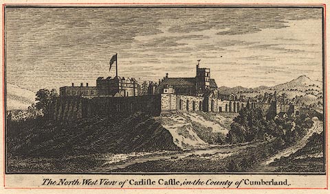
Print, engraving, North West View of Carlisle Castle,
late 18th century.
Pasted in the Lowther scrapbook, vol.3; between pp.228-229 ; with descriptive text (out of order in the scrapbook):- CARLISLE CASTLE / Is situated on the north-west side of the city of Carlisle, a place of considerable note in the earliest period of our history. It is said to have owed its origin to one Luel or Luguabal, an antient British King; and from thence to have derived the name given by the Britons, of Caer-Luel, or Luel's City. / When the Romans had extended their conquest to this extremity of the island, and raised that barrier against the incursions of their hostile neighbours, called the Pict's-wall, they changed the name of this city to Luguvallum, or the city of Luel on the Vallum or wall. / This place, being situated on the frontiers, and intended to check the progress of the northern invaders, must necessarily have been subject to the evils and calamities attendant on war: accordingly we find it was entirely destroyed by the Danes in the ninth century, and was not restored till the time that William Rufus, in 1092, in his progress through these parts, was so pleased with the situation, that he rebuilt and fortified the town, and strengthened it by the addition of a Castle of considerable extent. The fortifications were augmented, and a garrison placed here, by Henry I. It afterwards sustained many grievous seiges, was twice taken by the Scots, and as often recovered by the English. In the reign of Edward the second it was again besieged by Robert Bruce; and in the fourteenth of Richard II, it was almost entirely consumed by fire. / After this conflagration, in which the Castle must have suffered considerably, it was repaired and enlarged by king Richard III. Henry VIII. strengthened the fortifications of the town by the addition of a citadel. In this reign Musgrave and Tilby, who headed an insurrection raised on account of the suppression of monasteries, laid seige to this place with eight thousand men; but being repulsed by the city, were attacked and defeated in their retreat by the Duke of Norfolk. / In this Castle are shown the apartments where the unfortunate Mary Queen of Scots was lodged, when she took up her residence here, after her landing at Workington. It received some injury in the civil wars of Charles I.; was taken by the rebels in November 1745, and retaken by the Duke of Cumberland in about six weeks after. / The Print shows the entrance to the Castle, which is on the east side: this side is defended by a ditch, over which there was a draw-bridge when this view was taken, in 1777, but in some late repairs of the Castle an arch has been substituted in its stead. Over the outer gate, in the Print, is seen the stone on which, Cambden says, are the arms of Richard III. from whence it was supposed that he was the founder of this part of the Castle; and in the inner gate, is seen a part of the old portcullis mentioned by later topographical writers. / No.XI. |
||
| inscription:- |
printed bottom
The North West View of Carlisle Castle, in the County of Cumberland. |
|
| wxh:- | 139x79mm | |
|
from:- Scrapbook, 4 volumes, History of Westmorland and Cumberland Illustrated, of descriptive texts, maps, and prints of views and coats of arms, for Westmorland and Cumberland, assembled by a member of the Lowther Family, late 18th early 19th century. The volumes are quarter bound, with marbled paper on the covers; each has a bookplate inside the front cover. The pages cut from various sources are nicely mounted, two sided pieces set neatly in a window in the scrapbook page. The main content is the whole of the two volumes of The History and Antiquities of the Counties of Westmorland and Cumberland, by Joseph Nicolson and Richard Burn, published London, 1777. Nicolson and Burn volume 1 is in scrapbook volumes 1 and 2, volume 2 in scrapbook volumes 3 and 4. Maps and prints are interspersed to make an illustrated version of the history. Some of the sources of maps and prints have been recognised:- Maps - coast of Cumberland etc by Andrew Dury, 1764; Westmorland and Cumberland by Richard Blome, 1673; sheets from Britannia Depicta, Emanuel Bowen, 1720; Cumberland by John Speed, Henry Overton edn 1695; Cumberland by John Cary 1787. Prints from the Set of prints, 20 engravings, Views of the Lakes etc in Cumberland and Westmorland, drawn by Joseph Farington, published by William Byrne, London, 1789. Note that plate numbers vary from edition to edition of this set. Prints from the Antiquities of Great Britain, drawings by Thomas Hearne, engraved by William Byrne, published by Hearne and Byrne, London, 1786-1807. Prints from Britannia Illustrata, drawings by Leonard Knyff, engraved by John Kip, published London, 1707-1740. Print from A Tour in England and Scotland, by Thomas Newte, published by G G J and J Robinson, Paternoster Row, London, 1788.. Some of the coat of arms are cut from A Display of Heraldrie by John Guillim late Pursuivant at Armes, published London, about 1610-11 to 1755. Coats of arms probably from The Baronetage of England, by Edward Kimber and Richard Johnson, published London? 1771. Pages from The Antiquarian Repertory, by Francis Grose, Thomas Astle, et al, published London, 1775-1809. Text from the Baronetage of England by Collins? Scraps cut from an unidentified gazetteer. At the end is the title page and pp.7-51 from A General View of the Agriculture of the County of Cumberland, by John Bailey and George Culley, published by C Macrae, London, 1794. Individual maps and prints are documented separately; with a note of their position in the scrapbooks. inscription:- : embossed: label on spine: (tatty remains): HI[ ] / [ ]/WEST[ ]M[ ] / [ ] / CUM[ ]M[ ] / ILLUS[ ]T[E ] inscription:- : printed & embossed: bookplate: gold on grey; crest, 6 annulets from the coat of arms, flowers, thistles: LOWTHER |
||