 Brough Castle, Westmorland 1

|

|
|
|
item:- Dove Cottage : Lowther.32 image:- © see bottom of page |
click to enlarge |
|
|
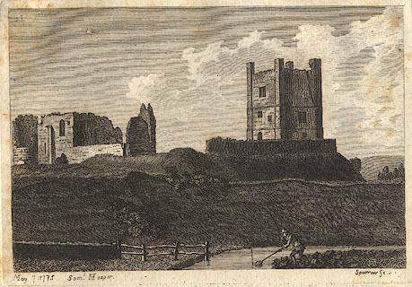
Print, engraving, Brough Castle, Westmorland, drawn by
Samuel Hooper, engraved by Sparrow, published by Samuel
Hooper, Ludgate Hill, London, 1775.
Included in The Antiquities of England and Wales, by Francis Grose. Pasted in the Lowther scrapbook, vol.2; between pp.464-466 (numbered 566); with descriptive text:- BROUGH CASTLE, WESTMORELAND. THIS castle stands near the north-east part of the county, and on the western bank of the river Eden. It is by some writers deemed a Roman building. Possibly a Roman fortress might have stood here before the Conquest; but the present edifice has incontestable marks of Norman origin. In the Additions to Camden, printed in Bishop Gibson's edition, the present structure is attributed to the Countess of Pembroke, if the following words are to be taken literally: "Here also stands the Castle of Brough, and a Tower called Caesar's Tower, or the Fort before-mentioned. The Castle, having been rased to the ground, was rebuilt, not long since, by the Countess of Pembroke." But that this is a mistake, is evident from an inscription formerly standing over the gateway, but now thrown down, and laid under the water-wheel of Brough Mill; of which this is a genuine copy: THIS castle of Brough under Stainmore, and the Great Tower of it, was repaired by the Lady Ann Clifford, Countess Dowager of Pembroke-Dorse, and Montgomery, Baron Clifford, Westmoreland and Visey, High Sheriff by inheritance of the County of Westmoreland, and Lady of the Honour of Skipton in Craven, in the year of our Lord God 1659; so as she came to lie in it herself for a little while in September 1661, after it had lain ruinous without timber, or any covering, ever since the year 1521, when it was burnt by a casual fire. Isa. chap. lviii. ver. 12. "God's name be praised." THE above Inscription manifestly proves that the repairs done by the Countess were chiefly internal, and that the ruins now seen are those of the original building: but by whom or when they were built, neither Leland, Camden, or any other of the Topographical Writers (at least those in print), mention; tho', as has been above observed, the similarity of its Keep to those of Dover, Bamborough, Rochester, the Tower of London, and many others, plainly evince it was constructed on the Norman model. THE present proprietor of these ruins is the Earl of Thanet. Of late years they have been much demolished for the sake of the materials, which have been used in building stables, garden walls, and other conveniences; and particularly about the year 1763, a great part of the north-east round tower was pulled down to repair Brough Mill, at which time the Mason therein employed, for the sake of the lead and iron with which it was fixed, displaced the stone which the Countess of Pembroke caused to be set over the gateway, on which was the inscription before cited. CAMDEN describing this country says, "Here Eden seems to stop its course, that it may receive some rivulets; upon one of which, scarce two miles from Eden itself, stood Verterae, an ancient town mentioned by Antoninus and the Notitia; from the latter of which we learn, that in the decline of the Roman empire a Praefect of the Romans quartered there with a band of the Directores. The town itself is dwindled into a village, which is defended with a small fort, and its name is now Burgh; for it is called Burgh under Stanmore, i. e. a Brough under a Stony Mountain. It is divided into two. The Upper, otherwise Church-Brough, where the Church standeth, of which Robert Eglesfield, Founder of Queen College in Oxford, was Rector, and procured the appropriation thereof from King Edward III. to the said College." - And again: "And near the Bridge is a Spaw-well, which hath not long been discovered. The other village is called Lower Brough, from its situation; and Market Brough from a market held there every Thursday. In the time of the latter Emperors (to observe this once for all) the Little Castles, which were built for the emergent occasions of war, and stored with provisions, began to be called Burgi; a new name, which, after the translation of the Empire into the East, the Germans and others seem to have taken from the Greek [ ]. And hence the Burgundians have their name from inhabiting the Burgi; for so that Age called the dwellings planted at a little distance from one another along the frontiers. I have read no more concerning this place, but that in the beginning of the Norman Government, the English formed a conspiracy here against William the Conqueror. I dare be positive that this Burgh was the Old Verterae; both because the distance, on one side from the Levatrae, and the other from Brovonacum, if resolved into Italian miles, exactly agrees with the number assigned by Antoninus; and also, because a Roman military road, still visible by its high ridge, runs this way to Brovonacum by Aballaba, mentioned in the Notitia; the name whereof is to this day kept so entire, that it plainly shews it to be the same, and leaves no ground for dispute; for instead of Aballaba we call it at this day by contraction Appleby." ANNO 1774, William King of Scotland taking advantage of the absence of King Henry, then in France, quelling a rebellion excited by his sons, invaded England at the head of an army, chiefly composed of Flemmings, and took this Castle, together with those of Appleby and Prudehow; but four hundred horsemen being assembled by Robert de Stouteville, Ralph Granville, William Vesey, Barnard Balliol, and Odenotte de Humfreville, they came up with the Scots, who were retiring from the seige of Alnwick; and finding them dispersed over the country in search of plunder, whereby they had left the King slightly guarded, they attacked, and with very little bloodshed on either side made him prisoner. THIS passage, which is mentioned by almost all our Historians, serves to shew that Brough-Castle was then in being; built, perhaps, at the time of the Conspiracy mentioned by Camden This View was drawn Anno 1774. |
||
| source type:- | Grose 1772-87 | |
| inscription:- |
printed bottom left, right
May 7 1775 Saml. Hooper. / Sparrow Sc. |
|
| wxh:- | 15.5x11cm | |
|
from:- Scrapbook, 4 volumes, History of Westmorland and Cumberland Illustrated, of descriptive texts, maps, and prints of views and coats of arms, for Westmorland and Cumberland, assembled by a member of the Lowther Family, late 18th early 19th century. The volumes are quarter bound, with marbled paper on the covers; each has a bookplate inside the front cover. The pages cut from various sources are nicely mounted, two sided pieces set neatly in a window in the scrapbook page. The main content is the whole of the two volumes of The History and Antiquities of the Counties of Westmorland and Cumberland, by Joseph Nicolson and Richard Burn, published London, 1777. Nicolson and Burn volume 1 is in scrapbook volumes 1 and 2, volume 2 in scrapbook volumes 3 and 4. Maps and prints are interspersed to make an illustrated version of the history. Some of the sources of maps and prints have been recognised:- Maps - coast of Cumberland etc by Andrew Dury, 1764; Westmorland and Cumberland by Richard Blome, 1673; sheets from Britannia Depicta, Emanuel Bowen, 1720; Cumberland by John Speed, Henry Overton edn 1695; Cumberland by John Cary 1787. Prints from the Set of prints, 20 engravings, Views of the Lakes etc in Cumberland and Westmorland, drawn by Joseph Farington, published by William Byrne, London, 1789. Note that plate numbers vary from edition to edition of this set. Prints from the Antiquities of Great Britain, drawings by Thomas Hearne, engraved by William Byrne, published by Hearne and Byrne, London, 1786-1807. Prints from Britannia Illustrata, drawings by Leonard Knyff, engraved by John Kip, published London, 1707-1740. Print from A Tour in England and Scotland, by Thomas Newte, published by G G J and J Robinson, Paternoster Row, London, 1788.. Some of the coat of arms are cut from A Display of Heraldrie by John Guillim late Pursuivant at Armes, published London, about 1610-11 to 1755. Coats of arms probably from The Baronetage of England, by Edward Kimber and Richard Johnson, published London? 1771. Pages from The Antiquarian Repertory, by Francis Grose, Thomas Astle, et al, published London, 1775-1809. Text from the Baronetage of England by Collins? Scraps cut from an unidentified gazetteer. At the end is the title page and pp.7-51 from A General View of the Agriculture of the County of Cumberland, by John Bailey and George Culley, published by C Macrae, London, 1794. Individual maps and prints are documented separately; with a note of their position in the scrapbooks. inscription:- : embossed: label on spine: (tatty remains): HI[ ] / [ ]/WEST[ ]M[ ] / [ ] / CUM[ ]M[ ] / ILLUS[ ]T[E ] inscription:- : printed & embossed: bookplate: gold on grey; crest, 6 annulets from the coat of arms, flowers, thistles: LOWTHER |
||