 Brougham Castle

|

|
|
|
item:- Dove Cottage : Lowther.20 image:- © see bottom of page |
click to enlarge |
|
|
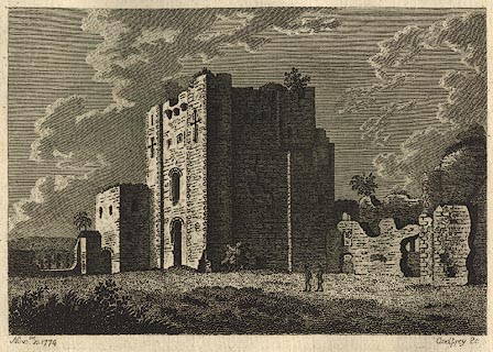
Print, engraving, Brougham Castle, Brougham, Westmorland,
engraved by Godfrey, 1774.
Pasted in the Lowther scrapbook, vol.2; between pp.396-397; with descriptive text:- BROUGHAM CASTLE, WESTMORELAND. / HISTORY has not recorded the Builder of this Castle, nor handed down to us the time when it was erected; but its stile of architecture, and particularly the Keep, indubitably pronounce it Norman. / IT is situated on the banks of the river Eimot, vulgarly pronounced Yeoman. Its remains shew it was once a strong, extensive, and beautiful edifice. The chief entrance is through a number of arches by the river-side. / THE following agreeable description of it is given in a late publication, intitled, / 'An Excursion to the Lakes.' / 'WE quited the high-road in order to pass by Brougham castle, a spacious ruin, situate on the banks of the river Yeoman. That we might enjoy the prospect to advantage, we crossed over the river, and made a sweep round the Mill which stands almost opposite to Brougham, from whence a view opened upon us delightfully. / 'The Mill, with its streams, lay on the fore-ground to the left;- a beautiful and shining canal, formed by the river Yeoman, margined with shrubs, laid spreading to the right;- in front, the streams which fell over the wear made a foaming cascade;- immediately on the opposite brink of the channel arises Brougham Castle.- Three square towers projecting, but yet connected with the building, form the front;- from thence, on either side, a little wing falls back some paces;- to the north-east a thick grove of planes and ashes block up the passage, and the gateway;- to the south-west the walls stretch out to a considerable distance along a fine grassy plain of pasture-ground, terminated by a tower, one of the out-posts of the Castle. In the centre of the building arises a lofty square tower, frowning in Gothic strength and gloomy pomp. The shuttered turrets which had formed the angles, and the hanging galleries which had communicated with each, were grown with shrubs and waving brambles. The sun-beams which struck each gasping loup, and bending window, discovered the inward devastation and ruin; and touched the whole with admirable colouring and beauty. To grace the landscape, fine groups of cattle were dispersed on the pasture; and through the tufts of ash trees, which were irregularly dispersed on the back ground, distant mountains were seen skirting the horizon. / 'THE lower apartment in the principal tower is still remaining entire; being covered with a vaulted roof of stone, consisting of eight arches which, as they spring from the side walls, are supported and terminate on a pillar in the centre. The apartment mentioned to have been in Bowes Castle, was assuredly of the same architecture; |
||
| inscription:- |
printed bottom left, right
Nov[br] 10 1774 / Godfrey Sc |
|
| wxh:- | 15.5x11cm | |
|
from:- Scrapbook, 4 volumes, History of Westmorland and Cumberland Illustrated, of descriptive texts, maps, and prints of views and coats of arms, for Westmorland and Cumberland, assembled by a member of the Lowther Family, late 18th early 19th century. The volumes are quarter bound, with marbled paper on the covers; each has a bookplate inside the front cover. The pages cut from various sources are nicely mounted, two sided pieces set neatly in a window in the scrapbook page. The main content is the whole of the two volumes of The History and Antiquities of the Counties of Westmorland and Cumberland, by Joseph Nicolson and Richard Burn, published London, 1777. Nicolson and Burn volume 1 is in scrapbook volumes 1 and 2, volume 2 in scrapbook volumes 3 and 4. Maps and prints are interspersed to make an illustrated version of the history. Some of the sources of maps and prints have been recognised:- Maps - coast of Cumberland etc by Andrew Dury, 1764; Westmorland and Cumberland by Richard Blome, 1673; sheets from Britannia Depicta, Emanuel Bowen, 1720; Cumberland by John Speed, Henry Overton edn 1695; Cumberland by John Cary 1787. Prints from the Set of prints, 20 engravings, Views of the Lakes etc in Cumberland and Westmorland, drawn by Joseph Farington, published by William Byrne, London, 1789. Note that plate numbers vary from edition to edition of this set. Prints from the Antiquities of Great Britain, drawings by Thomas Hearne, engraved by William Byrne, published by Hearne and Byrne, London, 1786-1807. Prints from Britannia Illustrata, drawings by Leonard Knyff, engraved by John Kip, published London, 1707-1740. Print from A Tour in England and Scotland, by Thomas Newte, published by G G J and J Robinson, Paternoster Row, London, 1788.. Some of the coat of arms are cut from A Display of Heraldrie by John Guillim late Pursuivant at Armes, published London, about 1610-11 to 1755. Coats of arms probably from The Baronetage of England, by Edward Kimber and Richard Johnson, published London? 1771. Pages from The Antiquarian Repertory, by Francis Grose, Thomas Astle, et al, published London, 1775-1809. Text from the Baronetage of England by Collins? Scraps cut from an unidentified gazetteer. At the end is the title page and pp.7-51 from A General View of the Agriculture of the County of Cumberland, by John Bailey and George Culley, published by C Macrae, London, 1794. Individual maps and prints are documented separately; with a note of their position in the scrapbooks. inscription:- : embossed: label on spine: (tatty remains): HI[ ] / [ ]/WEST[ ]M[ ] / [ ] / CUM[ ]M[ ] / ILLUS[ ]T[E ] inscription:- : printed & embossed: bookplate: gold on grey; crest, 6 annulets from the coat of arms, flowers, thistles: LOWTHER |
||