 Collins 1850

|

|
|
|
item:- JandMN (220) image:- © see bottom of page |
click to enlarge |
|
|
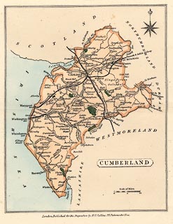
Map, coloured lithograph? Cumberland, scale about 11
miles to 1 inch, published by H G Collins, 22 Paternoster
Row, London, 1850.
|
||

|
Collins 1850 | |
| map feature:- | plain cartouche & compass rose & up is N & scale line & sea plain & coast tinted & rivers & lakes & parks & county & settlements & roads & railways & canals | |
| inscription:- |
printed title cartouche, lower right
CUMBERLAND |
|
| inscription:- |
printed bottom
London, Published for the proprietors by H. G. Collins, 22, Paternoster Row. |
|
| scale line:- | 10 miles = 22.9 mm | |
| scale:- | 1 to 700000 ? (1 to 702770 from scale line) | |
| wxh, map:- | 145x183mm | |