 Clarke and Collins 1852

|

|
|
|
item:- private collection (34) image:- © see bottom of page |
click to enlarge |
|
|
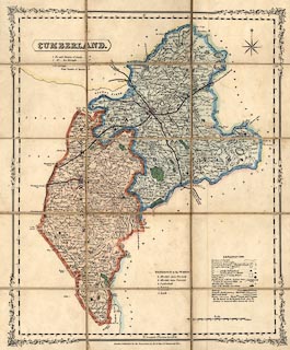
Map, hand coloured engraving? Cumberland, scale about 4.5
miles to 1 inch, published by H G Collins, Paternoster Row,
London, about 1850.
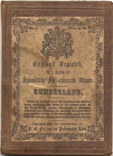
Sectioned for folding, mounted and folded in a card cover; no.7 in a series. |
||

|
Clarke and Collins 1852 | |
| map feature:- | decorative border & compass rose & up is N & scale line & lat and long scales & table of symbols & plain cartouche & sea plain & coast line & rivers & lakes & relief & hill hachuring & parks & county & wards (hundreds) & parishes & settlements & roads & turnpike roads & post roads & railways & canals & electoral data | |
| inscription:- |
printed title cartouche, upper left
CUMBERLAND. |
|
| inscription:- |
printed label on cover
No.7 Price 1s. 6d. / England Depicted, / In a Series of / Splendidly Full-coloured Maps. / CUMBERLAND. / Where, in addition to all the Railroads and Stations / being accurately laid down to the present time, all / the Coach Roads, canals, Boundaries of Divisions, / Hundreds, and Parishes, are carefully drawn to scale; / and also the number of Members each place returns / with the various polling places being severally shown. / PUBLISHED FOR THE PROPRIETORS, BY / H. G. Collins, 22 Paternoster Row. coat of arms, royal |
|
| scale line:- | 12+1 miles = 72.4 mm | |
| scale:- | 1 to 290000 ? (1 to 288971 from scale line) | |
| wxh, folded:- | 10x13.5cm | |
| wxh, cover:- | 10.5x14.5cn | |
| wxh, sheet:- | 38.5x48.5cm | |
| wxh, map (including gaps):- | 349x431mm | |
|
||