 Unknown 1600s

|

|
|
|
item:- JandMN (136) image:- © see bottom of page |
click to enlarge |
|
|
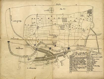
Map, uncoloured lithograph copy, Plan of Kirkby Kendall
ie Kendal, Westmorland, scale about 10 inches to 1 mile,
perhaps from a coloured original of the late 17th century.
|
||

|
Unknown 1600s | |
| map feature:- | compass rose & up is E & rivers & bridges & woods & settlements & roads | |
| inscription:- |
printed lower right, above a key of places
A Plan of Kirkby Kendall / with the Castle and Park Lands . ... |
|
| scale:- | 1 to 6000 ? (guess) | |
| wxh, map:- | 53x38cm | |