 Clarke 1787 map

|

|
|
|
item:- JandMN (56) image:- © see bottom of page |
click to enlarge |
|
|
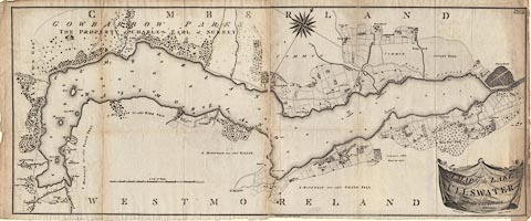
Map, A Map of the Lake Ullswater and its Environs, scale
about 6.5 ins to 1 mile, by James Clarke, engraved by S J
Neele, 352 Strand, London, published by James Clarke,
Penrith, Cumberland and in London etc, 1787.
Plate 4 in A Survey of the Lakes of Cumberland, Westmorland, and Lancashire. The map is printed on two sheets of paper which were pasted together on the binding tab, each sheet folded separately into the book. |
||

|
Clarke 1787 map | |
| map feature:- | drape cartouche & compass rose & up is NW (roughly) & scale line & rivers & lakes (form lines on coast) & woods & county & settlements & roads | |
| inscription:- |
printed title cartouche, lower right
A MAP of the LAKE / ULLSWATER / and its environs / Surveyed by / James Clarke |
|
| inscription:- |
printed above title cartouche, upper right
Engraved by S. Neele No 352 Strand London |
|
| inscription:- |
printed upper right
Plate 4 |
|
| inscription:- |
printed bottom
Published Feby. 10 1787, by James Clarke, Penrith. |
|
| scale line:- | 100 chains = 208.7 mm | |
| scale:- | 1 to 9600 ? (1 to 9639 from scale line) | |
| wxh, map:- | 1083x467mm | |