 Cruchley 1856

|

|
|
|
item:- JandMN (16) image:- © see bottom of page |
click to enlarge |
|
|
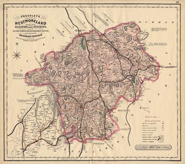
Map, coloured lithograph, Cruchley's County Map of
Westmoreland, scale about 2.5 miles to 1 inch, by George F
Cruchley, 81 Fleet Street, London, 1856, published by Gall
and Inglis, 25 Paternoster Square, London and George Street,
Edinburgh, about 1882?
There are geological comments around the edge of the map. |
||

|
Cruchley 1856 | |
| map feature:- | compass rose & up is N & scale line & lat and long scales & table of symbols & coast form lines & rivers & lakes & relief & hill hachuring & woods (?) & parks & county & settlements & roads & canals & railways & electric telegraph & geology | |
| inscription:- |
printed upper left
CRUCHLEY'S / COUNTY MAP OF / WESTMORELAND / Showing all the / RAILWAYS & NAMES OF STATIONS, / ALSO THE / VILLAGES, TURNPIKE ROADS, GENTLEMENS SEATS &c. &c. / Improved from the / ORDNANCE SURVEYS / LONDON : PUBLISHED BY GALL & INGLIS, 25, PATERNOSTER SQUARE. / EDINBURGH, 6 GEORGE STREET. |
|
| scale line:- | 8 miles = 86.4 mm | |
| scale:- | 1 to 150000 ? (1 to 149013 from scale line) | |
| wxh, map:- | 550x490mm | |