 Seale 1761

|

|
|
|
item:- JandMN (12) image:- © see bottom of page |
click to enlarge |
|
|
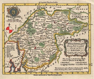
Map, hand coloured engraving, Westmoreland ie
Westmorland, scale about 7 miles to 1 inch, by R W Seale,
1761.
The map has the coat of arms of Appleby. Published in The Universal Magazine of Knowledge and Pleasure by John Hinton, Newgate Street, London, 1761. |
||

|
Seale 1761 | |
| map feature:- | baroque cartouche & coat of arms & compass rose & up is N & scale line & lat and long scales & table of symbols & sea plain & coast form lines & rivers & lakes & woods & relief & hillocks & county & wards (hundreds) & table of wards & settlements & roads | |
| inscription:- |
printed title cartouche, right below centre
WESTMORELAND, / Drawn from an actual / SURVEY / By R. W. Seale. / Universal Mag. J. Hinton, Newgate Street. |
|
| inscription:- |
printed above scale line
English Statute Miles |
|
| scale line:- | 10 miles = 35.6 mm | |
| scale:- | 1 to 450000 ? (1 to 452063 from scale line) | |
| wxh, sheet:- | 24.5x21cm | |
| wxh, plate:- | 224x182mm | |
| wxh, map:- | 212x172mm | |