 Bell 1833

|

|
|
|
item:- Dove Cottage : 2007.38.109 image:- © see bottom of page |
click to enlarge |
|
|
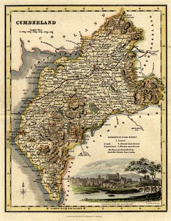
Map, hand coloured steel engraving, Cumberland, scale
about 8 miles to 1 inch, by James Bell? engraved by R Scott,
published by Archibald Fullarton and Co, Glasgow,
Strathclyde, about 1833.
Lower right is a vignette scene of Carlisle from the north east. Probably from A New and Comprehensive Gazetteer of England and Wales, by James Bell, 1833. |
||

|
Bell 1833 | |
| map feature:- | vignettes & compass rose & up is N & scale line & lat and long scales (West from Greenwich) & sea plain & coast shaded & rivers & lakes & relief & hill hachuring & forests & parks & county & wards (hundreds) & settlements & roads & canals | |
| inscription:- |
printed upper left
CUMBERLAND |
|
| inscription:- |
printed lower right
Engd. by R. Scott. |
|
| inscription:- |
printed bottom
Published by Archd. Fullarton & Co. Glasgow. |
|
| inscription:- |
printed with scale line
English Miles |
|
| scale line:- | 12 miles = 38.9 mm | |
| scale:- | 1 to 500000 ? (1 to 496456 from scale line) | |
| wxh, sheet:- | 25x30.5cm | |
| wxh, map:- | 189x239mm | |