 Philip 1857

|

|
|
|
item:- Dove Cottage : 2007.38.34 image:- © see bottom of page |
click to enlarge |
|
|
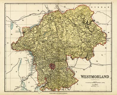
Map, colour lithograph, Westmorland, scale about 3 miles
to 1 inch, by Edward Weller, about 1857, published by George
Philip and Son, Liverpool, Merseyside and London, about
1876.
This is one of the first maps to be colour printed; probably first issued in Philips' County Atlas of England and Wales, 1857. The evidence of the railways suggest an edition about 1876, the Settle and Carlisle Railway, open 1876, is shown, but the Arnside to Hincaster branch, also open 1876, is drawn as being in progress. |
||

|
Philip 1857 | |
| map feature:- | up is N & scale line & table of symbols & lat and long scales (rectangular projection, W from Greenwich) & lat and long grid (5 minute) & index grid (using lat and long cells, A..F, 1..7) & sea tinted & coast line & rivers & lakes & relief & hill hachuring & parks & county & electoral data (little) & roads & canals & railways (updated from original) | |
| inscription:- |
printed lower right
WESTMORLAND / BY EDWD. WELLER F.R.G.S. |
|
| inscription:- |
printed bottom centre
GEORGE PHILIP & SON, LONDON & LIVERPOOL. |
|
| inscription:- |
printed top right
37 plate number |
|
| inscription:- |
printed bottom longitude scale
W. of Greenwich |
|
| inscription:- |
printed above scale line
English Miles |
|
| scale line:- | 8 miles = 71.9 mm | |
| scale:- | 1 to 180000 ? (1 to 179065 from scale assuming a statute mile) | |
| wxh, sheet:- | 50x37.5cm | |
| wxh, map:- | 410x339mm | |