 Walker 1830

|

|
|
|
item:- Dove Cottage : 2007.38.35 image:- © see bottom of page |
click to enlarge |
|
|
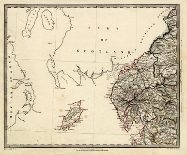
Map, hand coloured engraving, England No.2, Westmorland,
Cumberland, Isle of Man, etc, scale about 11 miles to 1
inch, engraved by J and C Walker, published by Charles
Knight and Co, for the Society for the Diffusion of Useful
Knowledge, 1845.
|
||

|
Walker 1830 | |
| map feature:- | up is N & scale line & lat and long scales (conical projection) & lat and long grid & sea plain & coast line & rivers & lakes & relief & hill hachuring & parks & county & settlements & roads & canals & railways | |
| inscription:- |
printed bottom, left, right, and centre
ENGLAND No.2 / Engraved by J. & C. Walker / Published by Charles Knight & Co. Novr. 1845. / Under the Superintendence of the Society for the Diffusion of Useful knowledge. |
|
| inscription:- |
printed with scale line
Statute Miles 69.1 = 1 Degree |
|
| scale line:- | 60+10 miles = 157.8 mm | |
| longitude, Kendal:- | 2d 44.5m W (approx) | |
| scale:- | 1 to 710000 ? (1 to 713904 from scale line) | |
| wxh, sheet:- | 43.5x35.5cm | |
| wxh, map:- | 389x316mm | |