 Bartholomew 1900

|

|
|
|
item:- JandMN (37_9) image:- © see bottom of page |
click to enlarge |
|
|
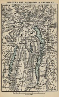
Map, Windermere, Coniston and Grasmere, scale about 2.5
miles to 1 inch, by John Bartholomew and Co, Edinburgh,
Lothian, about 1900.
Tipped in opposite p.66 in Black's Guide to the English Lakes, published by Adam and Charles Black, London, 23rd edn 1900. The map includes the area around Coniston Water, Esthwaite Water, Windermere, and Grasmere. |
||

|
Bartholomew 1900 | |
| map feature:- | north point & up is N & scale line & rivers & lakes & relief & hill hachuring & settlements & roads & railways | |
| inscription:- |
printed top
WINDERMERE, CONISTON & GRASMERE. |
|
| scale line:- | 4+1 miles = 50.7 mm | |
| wxh, sheet:- | 11X16.5cm | |
| wxh, map:- | 89x138mm | |
| scale:- | 1 to 160000 ? (1 to 158712 from scale line) | |