 Bartholomew 1900

|

|
|
|
item:- JandMN (37_20) image:- © see bottom of page |
click to enlarge |
|
|
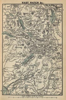
Map, Wast Water Etc, scale about 3.5 miles to 1 inch, by
John Bartholomew and Co, Edinburgh, Lothian, about 1900.
Tipped in opposite p.198 in Black's Guide to the English Lakes, published by Adam and Charles Black, London, 23rd edn 1900. The map includes the area from Ravenglas to Keswick with Derwent Water, Crummock Water, Ennerdale Water, Buttermere lake, and Wast Water. |
||

|
Bartholomew 1900 | |
| map feature:- | up is N & scale line & rivers & lakes & relief & hill hachuring & settlements & roads & railways | |
| inscription:- |
printed top
WAST WATER &c. |
|
| scale line:- | 10 miles = 74.5 mm | |
| wxh, sheet:- | 11X16.5cm | |
| wxh, map:- | 94x141mm | |
| scale:- | 1 to 220000 ? (1 to 216019 from scale line) | |