 Lewis 1835

|

|
|
|
item:- Hampshire Museums : FA2000.30.16 image:- © see bottom of page |
click to enlarge |
|
|
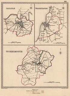
Map, political map, Carlisle, White Haven, and
Cockermouth, Cumberland, various ascale about 1-2 ins to 1
mile, drawn by R Creighton, engraved by J and C Walker,
published by S Lewis and Co, 87 Aldersgate Street, London,
1835.
Published in A Topographical Dictionary of England, 3rd edition vol.5 plate 16. |
||

|
Lewis 1835 | |
| map feature:- | compass rose & up is N & scale line & table of symbols & rivers & settlements & roads & canals & electoral data | |
| wxh, sheet:- | 32x32cm | |
| wxh, map:- | 184x237mm | |