 West 1784 map

|

|
|
|
item:- Dove Cottage : 2007.38.4 image:- © see bottom of page |
click to enlarge |
|
|
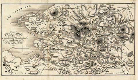
Map, uncoloured engraving, A Map of the Lakes in
Cumberland, Westmorland and Lancashire, scale about 3.5
miles to 1 inch, derived from Thomas West's map, 1784,
perhaps published London, about 1800s-10s.
Plate 9 from a book. |
||

|
West 1784 map | |
| map feature:- | north point & up is W & scale line & sea plain & coast shaded & rivers & lakes & relief & hill hachuring & parks & county & settlements & roads & sands roads | |
| inscription:- |
printed centre left
A MAP OF THE LAKES / IN / Cumberland, Westmorland / AND / LANCASHIRE. |
|
| scale line:- | 5 miles = 35.8 mm | |
| wxh, sheet:- | 35x20.5cm | |
| wxh, map:- | 335x182mm | |
| scale:- | 1 to 220000 ? (1 to 224769 from scale line assuming a statute mile) | |