 Mountains of South West of Derwentwater

|

|
|
|
item:- JandMN (48_5) image:- © see bottom of page |
click to enlarge |
|
|
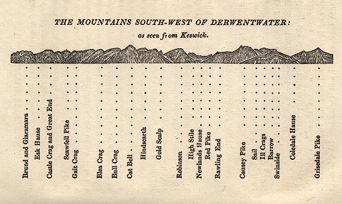
Print, woodcut outline view, The Mountains South West of
Derwentwater, by Jonathan Otley, Keswick, Cumberland, 1830.
Printed on p.21 of A Concise Description of the English Lakes, by Jonathan Otley, 5th edition, 1834. |
||
| source type:- | Otley 1823 (5th edn 1834) | |
| inscription:- |
printed top
THE MOUNTAINS SOUTH-WEST OF DERWENTWATER : / as seen from Keswick. |
|
| inscription:- |
printed bottom
Brund and Glaramara / Esk Hause / Castle Crag and Great End / Scawfell Pike / Gait Crag / Blea Crag / Bull Crag / Cat Bell / Hindscarth / Gold Scalp / Robinson / High Stile / Newlands Hause / Red Pike / Rawling End / Causey Pike / Sail / Ill Crags / Barrow / Swinside / Coledale Hause / Grisedale Pike |
|
| wxh:- | 13x7.5cm | |