 Panoramic Sketches from Scawfell Pike

|

|
|
|
item:- JandMN (28_9) image:- © see bottom of page |
click to enlarge |
|
|
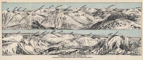
Print, lithograph, outline view, Panoramic Sketches from
Scawfell Pike, Cumberland, by Edwin A Pettitt, London,
published by Edward Stanford, 55 Charing Cross, London,
1875.
Tipped in opposite page 198 of A Practical Guide to the English Lake District, by Henry Irwin Jenkinson, 4th edition 1875. The upper scene shows from Pillar and High Stile across Grisedale Pike and Great Gable, Skiddaw, and Blencathra, to Helvellyn; the lower scene from the Langdale Pikes across Windermere, Coniston Old Man, Harter Fell, Duddon Estuary, and Scawfell to Wastwater. |
||
| source type:- | Jenkinson 1875 | |
| inscription:- |
printed bottom, left, centre and right
Edwin A. Pettitt, London. / PANORAMIC SKETCHES FROM SCAWFELL PIKE / Prepared for Jenkinson's Practical Guide to the English Lake District / Stanford's Geogl. Estabt., London |
|
| inscription:- |
printed in upper image
Pillar / Red Pike / High Stile / Black Sail Pass / High Crag / Kirk Fell / Lingmell / Whiteless Pike / Grasmoor / Hay Stacks / Robinson / Eel Crags / Piers Gill / Great Gable / Grisedale Pike / Hindscarth / Green Gable / Causey Pike / Dale Head / Grey Knotts / Maiden Moor / Skiddaw / Base Brown / Sty Head Tarn / Derwent Water / Castle Crag / Wallow Crag / Borrowdale / Brund Fell / Blencathra / High Street / Great End / Scawfell Pike (second) / Eagle Crag / Ullscarf / Scawfell Pike (first) / Helvellyn hill names |
|
| inscription:- |
printed in lower image
Langdale Pikes / Hanging Knott / Bow Fell / Windermere / Crinkle Crags / Wetherlam / Carrs / Coniston Old Man / Greyfriars / Dow Crags / Walney Scar / Hard Knott / Duddon Valley / Upper Eskdale / Harter Fell / Birker Moor / Black Combe / Scawfell / Mickledore Chasm / Wast Water hill names |
|
| wxh:- | 348x131mm | |