 Panoramic Sketches from Helvellyn

|

|
|
|
item:- JandMN (28_5) image:- © see bottom of page |
click to enlarge |
|
|
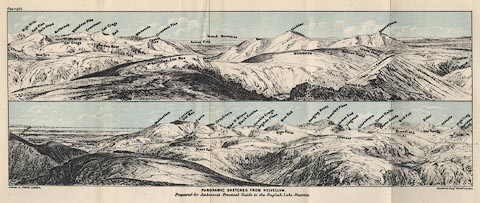
Print, lithograph, outline view, Panoramic Sketches from
Helvellyn, Westmorland, by Edwin A Pettitt, London,
published by Edward Stanford, 55 Charing Cross, London,
1875.
Tipped in opposite page 92 of A Practical Guide to the English Lake District, by Henry Irwin Jenkinson, 4th edition 1875. The upper scene shows from Ullscarf and High Stile, across Grisedale Pike, Solway Firth, Skiddaw, Blencathra, to the edge of Ullswater; the lower scene from Fairfield and Striding Edge, across Coniston Old Man, Langdale Pikes, Scawfell Pikes, Great Gable, to Honister Crag. |
||
| source type:- | Jenkinson 1875 | |
| inscription:- |
printed bottom, left, centre and right
Edwin A. Pettitt, London. / PANORAMIC SKETCHES FROM HELVELLYN / Prepared for Jenkinson's Practical Guide to the English Lake District / Stanford's Geogl. Estabt., London |
|
| inscription:- |
printed in upper image
Ullscarf / High Stile / Red Pike / Dale Head / Blea Tarn / Mellbreak / Hindscarth / Eel Crags / Whiteless Pike / Grasmoor / Maiden Moor / Eel Crags / Sail / Armboth Fells / Cat Bells / Whiteside / Causey Pike / Grisedale Pike / Helvellyn, Low Man / Solway Firth / Scotch Mountains / Bassenthwaite L. / Keppelcove Tarn / Skiddaw / Whiteside / Helvellyn / Swirrel Edge / Watson Dodd / Great Dodd / Blencathra / Catchedecam / Ullswater hill names |
|
| inscription:- |
printed in lower image
Red Tarn / Striding Edge / Fairfield / Windermere / Esthwaite Water / Coniston Lake / Wetherlam / Coniston Old Man / Carrs / Steel Fell / Greyfriars / Pike O' Blisco / Black Combe / Wythburn Head / Crinkle Crags / Langdale Pikes / High Raise / Bow Fell / Hanging Knott / Scawfell Pikes / Great End / Ullscarf / Lingmell / Glaramara / Great Gable / Green Gable / Kirk Fell / Brandreth / Harrop Tarn / Pillar / Hay Stacks / Steeple / High Crag / Honister Crag hill names |
|
| wxh:- | 346x131mm | |