 Panoramic Sketches from Skiddaw

|

|
|
|
item:- JandMN (28_8) image:- © see bottom of page |
click to enlarge |
|
|
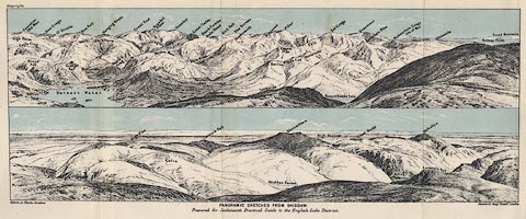
Print, lithograph, outline view, Panoramic Sketches from
Skiddaw, Cumberland, by Edwin A Pettitt, London, published
by Edward Stanford, 55 Charing Cross, London, 1875.
Tipped in opposite page 186 of A Practical Guide to the English Lake District, by Henry Irwin Jenkinson, 4th edition 1875. The upper scene shows from Coniston Old Man, across Scawfell, Great Gable, Grisedale Pike, to the a patch of the Solway Firth; the lower scene from the Solway Firth across High Pike, Blencathra, and Helvellyn. |
||
| source type:- | Jenkinson 1875 | |
| inscription:- |
printed bottom, left, centre and right
Edwin A. Pettitt, London. / PANORAMIC SKETCHES FROM SKIDDAW / Prepared for Jenkinson's Practical Guide to the English Lake District / Stanford's Geogl. Estabt., London |
|
| inscription:- |
printed in upper image
High Raise / Coniston Old Man / Eagle Crag / Brund Fell / Barrow / Lodore / Dow Crags / Pike O' Stickle / Derwent Water / Grange Fell / Bow Fell / Borrowdale Valley / Glaramara / Hanging Knott / Castle Crag / Great End / Sprinkling Fell / Cat Bells / Maiden Moor / Scawfell Pikes / Lingmell / Scawfell / Dale Head Glen / Great Gable / Newlands Vale / Swinside / Black Combe / Dale Head / Kirk Fell / The Screes / Hindscarth / Longside / Robinson / Barrow / Causey Pike / Pillar / Stile End / Outerside / Sail / Bassenthwaite Lake / Eel Crag / Grasmoor / Grisedale Pike / Hobcarton Crags / Isle of Man / Whiteside / Solway Firth / Scotch Mountains hill names |
|
| inscription:- |
printed in lower image
High Pike / Calva / Carrock Fell / Skiddaw Forest / Blencathra / High Street / Great Dodd / St. John's Vale / Helvellyn / Lonscale Fell hill names |
|
| wxh:- | 348x131mm | |