 Outline Views, Buttermere

|

|
|
|
item:- JandMN (37_19) image:- © see bottom of page |
click to enlarge |
|
|
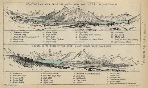
Print, lithograph, Outline Views, Buttermere - Mountains
as seen from the Knots near the Hotel at Buttermere, and
Mountains as seen at the Seat in Lanthwaite Wood, Scale
Hill, by J Flintoft, Keswick, Cumberland, engraved by R
Mason, Edinburgh, Lothian, about 1900.
Tipped in opposite p.188 of Black's Guide to the English Lakes, editor A R Hope Moncrieff, published by Adam and Charles Black, London, 23rd edn 1900. Each scene has a list of mountains keyed by number to the drawing. The Buttermere view includes Buttermere and Loweswater and the mountains behind from Buttermere Moss and honister Crag across High Stile, Red Pike etc, to Mellbreak and Rannerdale Knot. The Scale Hill view includes Crummock Water and the mountains behind from Grasmoor and Honister Crag across Mellbreak to Carling Knot, Burn Bank etc. |
||
| source type:- | Black 1856 | |
| inscription:- |
printed bottom, left and right
J. Flintoft, Keswick / R. Mason, Edinr. |
|
| inscription:- |
printed above upper image
MOUNTAINS AS SEEN FROM THE KNOTS NEAR THE HOTEL AT BUTTERMERE |
|
| inscription:- |
printed key to upper image
1 Buttermere Moss / 2 Honister Crag / Road to Borrowdale (below) / 3 Green Crag / 4 Green Gable / 5 Great Gable / 6 Hay Stacks / 7 Kirk Fell / Scarf Gap (below) / 8 High Crag / 9 High Stile / 10 Bleaberry Tarn (below) / 11 Red PIke / 12 Situation of Scale Force / 13 Scaw / 14 Floutern / 15 Hen Comb / 16 Mellbreak / Road to Scale Hill (below) / 17 Rannerdale Knot hill names |
|
| inscription:- |
printed above lower image
MOUNTAINS AS SEEN AT THE SEAT IN LANTHWAITE WOOD, SCALE HILL. |
|
| inscription:- |
printed key to lower image
1 Grasmoor / 2 Honister Crag / 3 Green Gable / 4 Great End / 5 Great Gable / 6 Rannerdale Knot / 7 Scaw Fell High Pike / 8 Kirk Fell / 9 High Crag / 10 High Stile / 11 Situation of Bleaberry Tarn / 12 Red Pike / 13 Mellbreak / 14 Hen Comb / 15 Scaw / 16 Middle Fell / 17 Blake Fell / 18 Carling Knot / 19 Loweswater (below) / 20 Burn Bank / 21 Road to Ennerdale & Wastwater hill names |
|
| wxh:- | 14.5x9cm | |